Cima/Peak: Vihren (2.914m)
Estacion/Season: Verano/Summer
Esta cima está situada en el Parque Nacional de Pirin, declarado Patrimonio de la Humanidad por la Unesco. Este, tiene unos 80 picos con más de 2.500m de altitud. Vihren, es la cumbre más alta de este macizo.
This peak is situated in the National Park of Pirin and declared Humanity Patrimoni by Unesco. This, have more than 80 peaks with more than 2.500m atitude. Vihren, is the highest top.
 |
| 1. Primer tramo del ascenso |
Nuestro viaje empieza en Bansko donde se coge una carretera que sube hacia Pirin. Son unos 10Km hasta llegar a la llamada Cabaña Vihren (хижа Вихрен), a 1950m de altura, lugar des del cual empezamos nuestro ascenso. Hay calculadas unas 3 horas hasta llegar a la cima pero puede variar según el ritmo de cada uno. En vez de coger el camino marcado para turistas, subimos por esta avalancha de rocas que podéis ver en la fotografía 1. Lugar muy difícil de ascender en el cual en ciertos tramos casi teníamos que escalar. La ventaja es que ahorras tiempo, puedes ver animales salvajes y encontrarte con alguna que otra fuente natural. Después de este gran esfuerzo nos merecíamos un descanso y paramos a llenar depósitos.
Our trip begins in Bansko where we took a car road going up to the mountain.The road is about 10 km and it arrives to the hut Vihren (1950m). From there started our trip walking. Aproximately there are 3 hour to reach the top but it depends on you. In spite of taking the marked tourist path we went up throught а dry river which was going straight up (photo 1). If you want to take this path you have to be avare that there are two path going up but only one is good (it have big stable stones good to walk). This path is nice because it saves time you can find fresh water and tracks of wild animal. Difficult place to walk where we had almost to climb. After this effort we deserve a break to fill our deposits and enjoy the views.
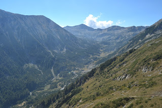
Paisajes como estos te vas encontrando por el camino (foto 2 y 3). Como podéis ver con vegetación muy variada. Hay dos opciones para ascender a la cima, ir por el camino fácil corto y marcado o rodear la montana e ir por la cara norte, opción mas extrema. La decisión fue fácil, descubrir la cara norte.
When we got up to the tourist path the hut was like a toy. As you can see, the vegetation is varied (photo 2 and 3). We had two options to go through the easy and short south side of the peak or do a round and go throught the north side which is a more steep and extreme but a lot more beautiful. The choise was easy, north side. We were still far from our goal. We had to do a round of the peak going streight instead of going up.
 |
| 2 |
 |
| 3 |
After 30 min we arrived to this point (photo 4). It was finally time to go up. But the first thing you think is " this is impossible". But we didn't give up we went streight up.The sky was amazing blue.
La cima que se ve al otro lado se llama Kutelo (foto 5) (2907m) la cual se puede hacer seguidamente siguiendo la cresta. Este camino se llama el Caballo. Es un camino de 1 metro de ancho en el cual hay cables de seguridad. Si lo que buscas es un poco de emoción, esta es tu ruta.
 |
| 4 |
The peak you can see from the other side is called Kutelo(Кутело) (photo 5) 2907m from there you can take a path going down through the edge. Its called The horse(Кончето). Its a path about 1m wide it have cables to hold. Its one of the most difficult so if you are looking for adrelina there is your destination.
 |
| 5 |
We were almost climbing for 40 min when finally we saw the horizont. We were on the top.The altitude was 2914m and you we had the best sides to watch and enjoy from every corner of the peak. (foto 6 and 7)
 |
| 7 |
La bajada es mas suave ya que por el camino te puedes ir encontrando alguna que otra sorpresa. (foto 8 y 9)
The descent was more gentle because by the way you can find some surprise how you see in the following photos (8 and 9).
Después de un merecido descanso continuamos nuestro descenso por la parte sur. Donde pudimos ver un lago llamado Vlahinski (foto 10). Desde allí en 40 minutos llegábamos a la cabaña Vihren.
 |
| 8 |
 |
| 9 |
After a deserved rest and many photos we continue your journey going down the south side of the peak. There was a beautiful lakes called Vlahinski(Влахински) this one is the biggest and the most beautiful (photo 10). From there for 40 min we were at hut Vihren again we took a deserved rest and we head home.
 |
| 10 |
Muchas gracias.
If you have any question, leave a comment.
Thank you.


No hay comentarios:
Publicar un comentario