jueves, 5 de septiembre de 2013

Melnik

Habitantes/ Habitants: 208
Municipio/ Municipality: Sandanski
Provincia/ County: Blagoevgrad
Distancia a la capital/ Distance to the capital: 175km


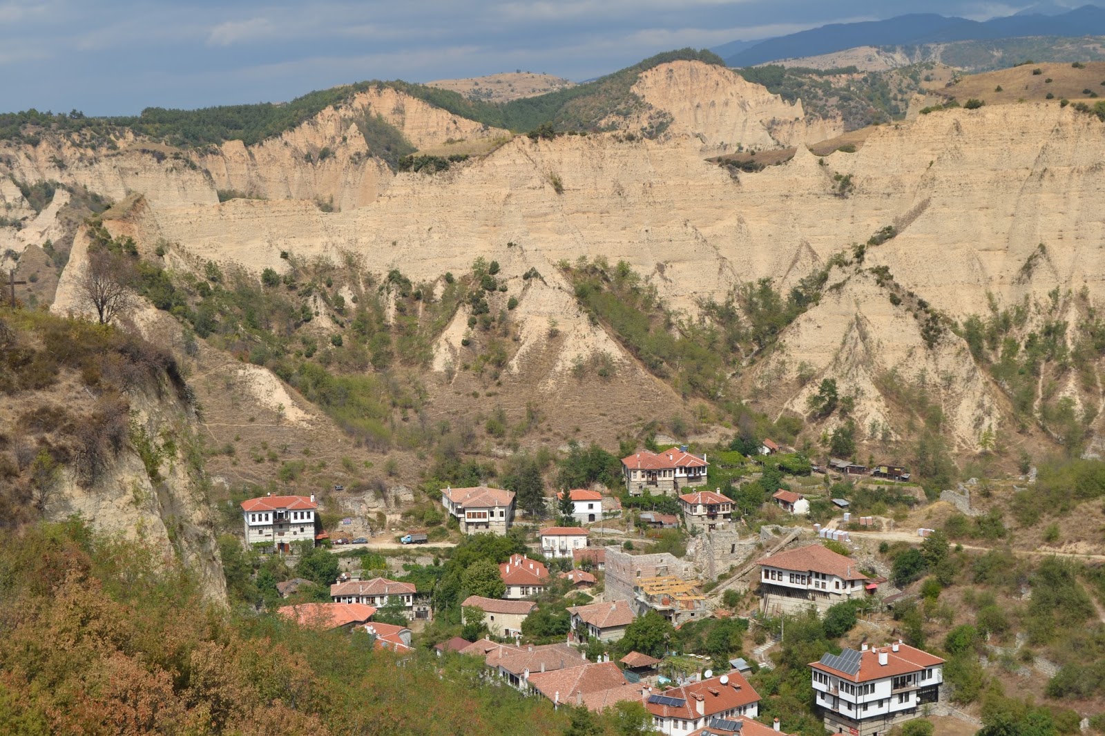
Melnik es la ciudad más pequeña de Bulgaria, aún se la llama ciudad por motivos históricos.
El nombre Melnik viene de la palabra eslava "mel" la cual significa barro blanco, por las pirámides que le rodean. Estas pirámides fueron declaradas monumento natural en 1978.

Melnik is the smallest town in Bulgaria, is called town because of historical reasons.
The name of Melnik comes from the Slavonic word "mel" which means white clay, because of the surrounding sand pyramids. This pyramids were declared a natural landmark in 1978.


Diversos hallazgos muestran la historia de este lugar. Como por ejemplo un puente romano.
Podemos ver también las murallas de la fortaleza de Despot Alexius Slav, gobernador de Melnik cuando se independizo en 1215. 

The finds from the antiquity discovered upon the archaeological diggings testify for its centuries-old history. For example an ancient Roman bridge.
In 1215 Melnik turned into a capital of an independent feudal principality, ruled by Despot Alexius Slav. The ruins of his fortress are preserved to the present days, near the town.


Una de las casas más viejas en los Balcanes es la casa Boyar (declarada monumento arquitectónico en 1965), la cual fue residencia de Despot Alexius Slav. A mediados del siglo XIII fue quemada y más tarde reconstruida.

One of the oldest houses on the Balkan Peninsula is the Boyar’s House (declared an architectural monument in 1965), which was a residence of Despot Alexius Slav. In the middle of the 13th century a part of it was set on fire and destroyed, and during the following centuries it was restored and reconstructed.


Otras dos casas declaradas monumentos arquitectónicos son la casa Kordopulova (el edificio más largo del resurgimiento Nacional Búlgaro  y la casa Pashova (construida en 1815). 
Other two houses which are declared architectural monuments of the Revival are the Kordopulova House (the largest building from the Bulgarian National Revival) and the Pashova House (built in 1815). 


Iglesia St. Nicholas, cerca de Melnik. Solo la pared oeste se conserva y algunos elementos en el interior.
Church Sant Nicholas, near the town of Melnik. Only the west wall is preserved and a few elements of the interior of the church.


Aqui podemos ver Konak, la residencia abandonada del governador turco.
Here is the Konak, the abandoned former residence of the turkish governor.

Melnik es también famoso en Europa entera por su tan preciado vino, hecho desde el 1346. Algo que no te puedes perder!

Melnik also became famous in entire Europe for its good wine, they make it since 1346. Something you can't miss!


Yordan DV & Núria DG

martes, 3 de septiembre de 2013

Stob Pyramids

Stob (el pueblo)/ Stob (the village)


Coordenadas/Coordinates: 42º05'43"N 23º06'16"E
Situación/ Location: South-Western Bulgaria
Distancia a la capital/ Distance to the capital: 68.7Km (Sofia)
Altitud/Altitude: 300-499m del nivel del mar/ above sea level
Provincia/ Province: Kyustendil District
Municipio/ Municipality: Kocherinovo Municipality
Area: 20.323km2
Población/ Population: 716 (2012)

Pueblo situado a los pies de las montañas de Rila y cerca del monasterio de Rila.
Distancia de unos 6km de la ruta europea E79, que conecta eñ pueblo con los pueblos de Dupnitsa, Blagoevgrad y Sofía.
El relieve es medio montañoso y el clima es de tipo continental, caracterizado con inviernos frios y veranos cálidos y secos.
La iglesia del pueblo tiene exclusiva arquitectura St. Prokopiy. Fue construida en 1873 y los valiosos murales e iconos están bien conservados.
Stob es conocido por sus pirámides, un fenómeno natural rocoso.

Village located at the foot of the Rila mountains and not far from the Rila Monastery.
About 6km away is the European route E79, connecting the village to the towns of Dupnitsa, Blagoevgrad and Sofia.
The relief is mid-mountainous and the climate in the region is continental, characterized with mild winters and warm and dry summers. 
The village church with unique architecture St. Prokopiy was buit in 1873 and the valuable murals and icons there are well preserved.
Stob is notable for the Stob Pyramids, a natural rock phenomenon in the vicinity of the village. 


Stob Pyramids: 

Se trata de formaciones de piedra y tierra de 30 a 40m de profundidad que se encuentran a 7km al noreste de la aldea. Los sedimentos son de color naranjoso debido a su ubicación.
Están bajo protección del Estado desde 1964.
Son formaciones rocosas de hasta 12m de altura. Tienen una forma cónica parecida a una seta. Algunas de las columnas están coronadas por piedras planas.
Algunas de las pirámides tienen nombre como Las Torres, Los Pináculos y las Chimeneas Samodiva.
Según una leyenda popular, se dice que las pirámides son invitados de boda petrificados por la belleza de la novia. La población local identifica algunas de las pirámides como el novio, la novia y otros asistentes a la ceremonia.

¡Especialmente hermosas al atardecer!


These are stone and earth formations, 30-40m deep, located 7km to the northeast of the village. The sediments are coloured orange because of their location.

The Pyramids have been under state protection since 1964 as a protected site.
The pyramids are rock formations up 12m high and around 40cm thick at the base. They vary shape from sharp through conical to mushroomlike. Some of the columns are topped by flat stones.
Groups of individual Pyramids have been named The Towers, The Pinnacles and Samodiva Chimeneys.
According to a popular local legend, the pyramids are in fact wedding guests who were petrified because the bride was so beautiful that the best man attempted to kiss her. Based on the legend, the local population has identified some of the pyramids as the best man, the groom, the bride and other attendants of the wedding ceremony.

The pyramids are especially beautiful at sunset or at moonlight!


Yordan DV & Núria DG